
Project 7:
Assess the SunGuide® and STEWARD Databases
Objective
Evaluate the feasibility of using the existing software and data bases as platforms for analyzing the attributes of electric vehicles within present and future transportation infrastructure projects and models.
Brief Description
This project evaluated the feasibility of using the existing software and data bases as platforms for analyzing the attributes of electric vehicles within present and future transportation infrastructure projects and models. The Florida based SunGuide and STEWARD databases were found to be abandoned and outdated. The Regional Integrated Transportation Information System (RITIS) database was used to provide current vehicle information on the Florida Turnpike for a transportation simulation model (Project #13). Multiple measurement locations on the Florida Turnpike provided vehicle volume, speed, and direction which were used as detailed input for transportation simulation models. Activities to date include review and formatting of RITIS vehicle transport data to provide inputs for a Florida Turnpike transportation model and coordination with UCF to revise vehicle transport data as needed for model development. The report completes this project effort.
Research Results
The project has documented information from the Regional Integrated Transportation Information System (RITIS) database in a format readily adaptable to transportation modeling. This information supplied project modelers with the methodology for accessing and filtering stored vehicle transport data to provide the basis for advanced modeling of transport systems.
The Center for Advanced Transportation Technology (CATT) laboratory at the University of Maryland integrates, archives, and processes transportation data feeds from agencies across the country. This information is shared with various private and public agencies to communicate current and historical transportation information. The three main components to the RITIS system are: 1) real-time data feeds, 2) real-time situational awareness tools, and 3) archived data analysis tools. Access to the RITIS web site (ritis.org) requires Department of Transportation (DOT) authorization when used by non-DOT entities and requires a username and password (data is considered sensitive). The site interactively provides a variety of information as maps, lists, and graphical displays. Archived data can be exported for independent analysis.
For purposes of transportation modeling, archived transit data for vehicle volume and speed were collected for specific locations on the Florida Turnpike. Table 1 shows an example of the exported data as received from the RITIS archive. Figure 1 shows an example of a single measurement location on the Florida Turnpike for vehicle speed and post-processed hourly vehicle volume.
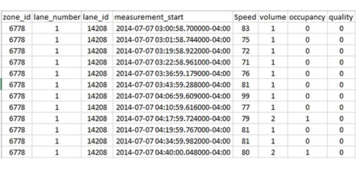 |
| Table 1. Example RITIS Export Data Format |
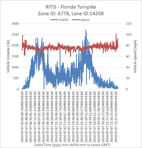 |
| Figure 1. Example RITIS Post-Processed Vehicle Volume and Speed Information |
The data collected were used as input to the Florida Turnpike transportation model and were organized according to the zone ID and lane location (see Table 1). These data were initially non-chronological and required organizational post-processing. Additionally, other key metrics (e.g., vehicle volume per hour) also required post processing to calculate the desired value. For example, using the vehicle speed data and associated time stamp, a vehicle volume per hour could be calculated.
Use of multiple locations on the Florida Turnpike (i.e., zone ID) provided a macroscopic view of vehicles traveling along this roadway. Figure 2 shows a schematic representation of roadway throughway, exit and entrance. The RITIS data were used to define these model inputs for Florida Turnpike plazas (Figure 3) to determine queuing information for optionally locating EV charging stations.
The Florida Turnpike also collects one-time measurements annually to document plaza volume as a percentage of roadway volume. This data were used to define the potential plaza entrance volume based on RITIS archive data. For example, a specific service plaza may have approximately 10% volume based on roadway thoroughfare. This percentage multiplied by the RITIS measurement, along with an estimation of the percentage of EV's traveling the roadway provided an input to the EV charging station queuing model.
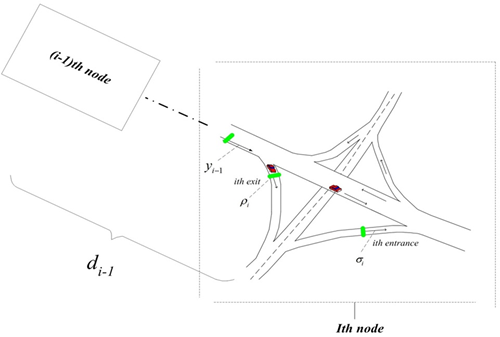 |
| Figure 2. Schematic Representation of Nodal Transportation Model |
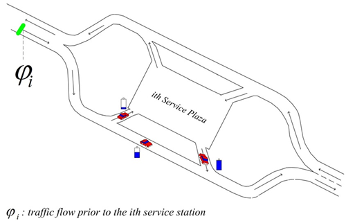 |
| Figure 3. Florida Turnpike Service Plaza Transport Model |
Further refinement of model inputs will be discussed with Florida Turnpike personnel to improve model output regarding siting of EV charging station number and location at service plazas along the Florida Turnpike and other roadways.
Impacts/Benefits
The use of historical measured transportation vehicle information allows more accurate modeling of transportation systems. Although this data may be protected due to sensitive information, agencies working with DOT can have access to these historical transport measurements.
Reports
Gusrialdi, A., Qu, Z., Simaan, M. (2014). “Scheduling and cooperative control of electric vehicles’ charging at highway service stations.” Decision and Control, 2014 IEEE 53rd Annual Conference. DOI: 10.1109/CDC.2014.7040403.
Raustad, R. (2017). "Assessing the SunGuide® and STEWARD Databases". Florida Solar Energy Center, Report No. FSEC-CR-2054-17.
Project Title: University: Principal Investigator: PI Contact Information: Florida Solar Energy Center Funding Source: Total Project Cost: Agency ID or Contract Number: Start date: End date: |